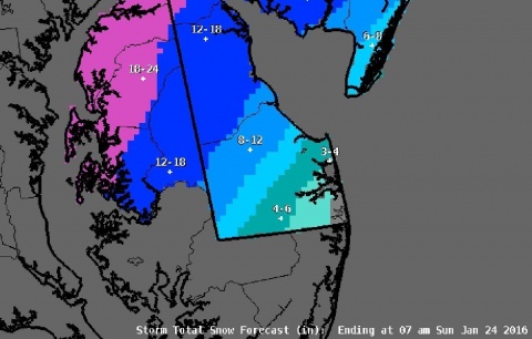
Georgetown, Del. (5:30 p.m. Fri., Jan. 22, 2016): The first flakes of a major winter storm are falling across Sussex County, the early signs of what could be days of heavy precipitation – snow, sleet and rain – as well as significant coastal flooding and high winds, all of which combined could stall travel, cut off communities and leave homes in the dark.
The National Weather Service in Mt. Holly, N.J., has issued a winter storm warning for Sussex County through Sunday morning, Jan. 24, for 4 to 9 inches of snow. In coastal areas, lesser amounts are expected as warmer air from the Atlantic Ocean mixes in, while inland locations to the northwest could see totals approach a foot if an expected changeover to rain is limited. A coastal flood warning and high wind warning are also in effect for the county.
Delaware Gov. Jack Markell has issued a state of emergency, effective immediately, and urged motorists to avoid travel if at all possible.
While snow is a concern with any winter storm, the major effects of this nor’easter could be prolonged 50 mph northeasterly winds and moderate to severe coastal flooding along the beaches and Inland Bays, where tides could run as much as 4 feet above normal. The storm’s expected strength and slow track, along with a full moon this weekend, are expected to push water into low-lying communities through at least Sunday evening, forecasters predict.
Sussex County will activate its Emergency Operations Center at 6 a.m. Saturday, Jan. 23, with staff monitoring the storm and conditions, and responding to any issues, as needed. County officials continue to monitor the developing storm and are in contact with state emergency planners and forecasters for the latest information. Meantime, the Delaware National Guard has pre-positioned equipment, including heavy duty vehicles, to assist in any storm-related issues.
No evacuations have been ordered, and no shelters have been designated at this time. However, residents in vulnerable, flood-prone areas should move to higher ground, if necessary.
“Hopefully, the public has heeded the warnings and made the necessary preparations. Now we wait to see what unfolds,” Sussex County EOC Director Joseph L. Thomas said. “My greatest concern continues to be flooding in our coastal communities, particularly during the times of high tide at 8 o’clock Saturday morning and again Saturday night. This could rank up there with some of the historic nor’easters of the past, including the 1992 and 1998 storms, when we had flooding that lasted several days.”
“The public should continue to monitor the forecasts, stay off the roads and sit this one out,” Mr. Thomas said. “It could be a messy couple of days.”
In addition to flooding, power outages could be another problem with downed trees and lines caused by strong, gusty winds. Forecasters expect northeasterly winds to whip along the coast and inland, with gusts possibly reaching 50 to 60 mph, throughout Saturday before lessening early Sunday morning.
For updates, stay tuned to local television and radio stations, as well as the Sussex County website at sussexcountyde.gov. The public also should monitor the National Weather Service, at www.weather.gov/phi for the latest forecasts.
Meantime, Sussex County offers a variety of social media outlets, which are a great resource for up-to-date storm information. Please follow along at: www.facebook.com/SussexCountyDE, www.facebook.com/SussexCountyEOC, and www.facebook.com/SussexCountyEMS on Facebook; and twitter.com/sussexde_govt, twitter.com/SussexCtyDE_EOC, and twitter.com/SussexCoDE_EMS on Twitter.
Beginning at 6 a.m. Saturday, anyone with non-emergency questions or in need of additional information can call the Sussex County EOC’s storm information hotline at (302) 856-7366.
###
Media calls should be directed to EOC spokeswoman Debra Jones at (302) 855-7801 or Sussex County Communications Director Chip Guy at (302) 858-0505.
