
2 PM, Saturday, Oct. 3, 2015: Sussex County continues to take the brunt of a lingering coastal storm that shows little sign of letting up, at least for the moment, as stiff onshore winds are still pushing water into low-lying communities that have sustained days of flooding and higher than normal tide cycles.
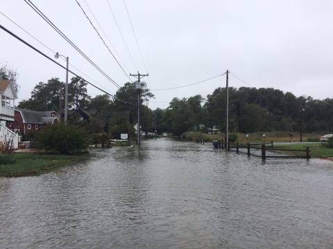
A coastal flood warning and limited state of emergency remain in effect for Sussex County, with moderate flooding occurring, particularly in low-lying communities along the Delaware and Inland bays. While heavy rains have moved on, for the most part, forecasters with the National Weather Service expect the nor’easter to continue affecting the Delmarva Peninsula today and into Sunday with gusty winds and higher-than-normal tides. Winds could remain gusty, up to 40 mph along the coast, into Sunday, and tides are expected to run as much as 2 to 4 feet above normal.
Meantime, Hurricane Joaquin, a Category 4 storm with sustained winds of 155 mph is expected to remain well off the East Coast as it heads out to sea. The hurricane, though, could still have an influence on Sussex County beaches later this weekend and early next week, with rough surf and beach erosion as the primary effects.
Sussex County has received reports of some downed trees and branches, with some spotty power outages, but tidal flooding is the most persistent issue. While a limited state of emergency remains in effect, there are no evacuation orders or travel restrictions. However, motorists should exercise caution if traveling, and those living in low-lying areas should expect flood waters to affect their communities for several tide cycles through at least Sunday.
“We are continuing to push our way through this storm, and hopefully as the next 24 to 36 hours progress, the conditions will begin to improve,” Sussex County Emergency Operations Center Director Joseph L. Thomas said. “But the areas that are flooded now should expect to see that flooding continue through at least the next two or three tide cycles, and after that, as the storm pulls away, some of the water backed up into the bays should begin to drain and conditions should improve.”
The Sussex County EOC continues to monitor the situation, and encourages residents and visitors to remain up to date on conditions in the county. Updates will be issued as conditions warrant.
For updates, stay tuned to local television and radio stations, as well as the Sussex County website at sussexcountyde.gov. The public also should monitor the National Weather Service, at www.weather.gov/phi and the National Hurricane Center at www.nhc.noaa.gov for the latest forecasts.
Meantime, Sussex County offers a variety of social media outlets, which are a great resource for up-to-date storm information. Please follow along at: www.facebook.com/SussexCountyDE, www.facebook.com/SussexCountyEOC, and www.facebook.com/SussexCountyEMS on Facebook; and twitter.com/sussexde_govt, twitter.com/SussexCtyDE_EOC, and twitter.com/SussexCoDE_EMS on Twitter.
For more information, please contact the Sussex County EOC’s storm information hotline at (302) 856-7366.
###