
Georgetown, Del. (5 p.m. Fri., Sept. 2, 2016): An unwelcomed guest is threatening to ruin more than summer’s last hurrah, as Tropical Storm Hermine is expected to breeze into the region this Labor Day weekend and then linger about, bringing with it up to 5 inches of rain, 50 mph winds, major beach erosion, dangerous rip currents and moderate to severe flooding that could batter coastal communities over several days.
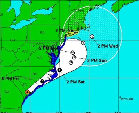
Forecasters with the National Weather Service expect the storm to make its way off the southeast U.S. coast by early Saturday, after raking the Florida Panhandle and the Carolinas with torrential rains, damaging winds, and rough surf. Once off shore, though, it could sit and spin, putting Sussex County and the rest of the Mid-Atlantic through a wash-rinse-and-repeat cycle that will see waves of heavy rain, rough surf and gusty winds push ashore through at least Labor Day.
The National Hurricane Center has issued a tropical storm warning for Sussex County until further notice. The storm’s projected track just off the Delmarva Peninsula, where it is forecast to stall, could mean days of strong onshore winds piling up water along Delaware’s beaches and inland bays, likely flooding low-lying areas and cutting off access in some places.
At this time, no evacuations have been ordered, and no shelters have been designated. However, the Sussex County Emergency Operations Center, which is actively monitoring the situation, is cautioning those in vulnerable areas to be ready and think about relocating to higher ground, if necessary.
“Sussex County may escape a direct hit, but the prolonged effects of this storm may be just as bad if not worse,” Sussex County EOC Director Joseph L. Thomas said. “Two to three days of rain, winds and tidal surge could really cause a lot of trouble for the beaches and low-lying communities. If this storm parks itself off our doorstep, whether it’s a direct hit or a glancing blow it really doesn’t matter. We’ll have flooding, wind damage, road closures, power outages, everything you would expect. The public should prepare now for those likely possibilities.”
The Sussex County EOC encourages residents and visitors to continue monitoring the forecast and conditions as they deteriorate.Sussex County cautions those planning to visit the area for the long holiday weekend to carefully monitor conditions and adjust accordingly. Campers in area parks should also monitor the forecasts, and be prepared to leave if ordered to do so.
Areas that historically flood, including Long Neck, Broadkill Beach and Primehook, could see moderate to severe flooding through at least Labor Day with tides as much as 2 to 4 feet above normal.
Conditions are expected to begin deteriorating Saturday morning and could last through at least Sunday evening, if not longer. All will depend on how much the storm re-strengthens and what track it takes – if it takes a more easterly track away from the coast, the effects of wind, rains and flooding likely would lessen.
Residents, visitors and property owners should take time now to secure loose objects, such as lawn chairs and trash cans, to prevent winds from turning those items into projectiles. Also, residents and visitors in low-lying areas should make sure submersible pumps are working and check storm drains to ensure they are clear of debris.
For updates, stay tuned to local television and radio stations, as well as the Sussex County website at sussexcountyde.gov. The public also should monitor the National Weather Service, at www.weather.gov/phi and the National Hurricane Center at www.nhc.noaa.gov for the latest forecasts.
Meantime, Sussex County offers a variety of social media outlets, which are a great resource for up-to-date storm information. Please follow along at: www.facebook.com/SussexCountyDE, www.facebook.com/SussexCountyEOC, and www.facebook.com/SussexCountyEMS on Facebook; and twitter.com/sussexde_govt, www.twitter.com/SussexCtyDE_EOC, and www.twitter.com/SussexCoDE_EMS on Twitter.
###
Media calls should be directed to EOC spokeswoman Debra Jones at (302) 855-7801 or Sussex County Communications Director Chip Guy at (302) 858-0505.