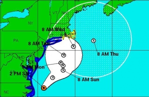
Georgetown, Del. (3 p.m. Sat., Sept. 3, 2016): The first effects of what was once Tropical Storm Hermine have left parts of Sussex County a bit soggy, but otherwise no worse for wear, to start the Labor Day weekend. However, the storm’s uncertain track and a possible shift back toward the Mid-Atlantic later this weekend still threatens to cause serious problems, including major coastal flooding and significant beach erosion that could last days.
The National Hurricane Center and National Weather Service continue to warn of major coastal effects along much of the Eastern Seaboard. Tides over several cycles – particularly at times of high tide on Sunday night and again Monday morning – could run as much as 3 to 5 feet above normal along Sussex County’s beaches, as well as in the Delaware and Inland bays.
As of 2 p.m. Saturday, the storm was located off the North Carolina/Virginia coast, with winds at 70 mph, moving to the east-northeast. It is expected to stall, however, about 150 miles off the Delaware/New Jersey coast, where it could meander through at least Tuesday and re-intensify to hurricane strength.
With the continual counter-clockwise flow around the storm, an expected period of strengthening and little movement in position, northeasterly winds will push water and waves into the coast and back bays, scouring beaches, flooding low-lying areas and potentially cutting off access in some places. Tropical storm-force winds and heavy rains are expected to remain mostly off-shore, but a slight shift in the track to the west could bring those effects inland.
A tropical storm warning remains in effect for Sussex County until further notice. Meantime, Delaware Gov. Jack Markell has issued a limited state of emergency for Sussex County, effective 5 p.m. Saturday, allowing the National Guard to pre-position equipment and personnel.
While no evacuations have been ordered and no shelters have been designated, the Sussex County Emergency Operations Center reminds those in vulnerable and low-lying areas to consider relocating, if necessary. Areas that historically flood, including Long Neck, Broadkill Beach and Primehook, could see moderate to severe flooding through at least Labor Day, but possibly longer if the storm remains near stationary through mid-week.
The Sussex County Emergency Operations Center continues to monitor the developing situation, and is working closely with Delaware emergency planners, the National Guard, and local fire companies to have personnel and equipment at the ready for any response.
For updates, stay tuned to local television and radio stations, as well as the Sussex County website at sussexcountyde.gov. The public also should monitor the National Weather Service, at www.weather.gov/phi and the National Hurricane Center at www.nhc.noaa.gov for the latest forecasts.
Meantime, Sussex County offers a variety of social media outlets, which are a great resource for up-to-date storm information. Please follow along at: www.facebook.com/SussexCountyDE, www.facebook.com/SussexCountyEOC, and www.facebook.com/SussexCountyEMS on Facebook; and twitter.com/sussexde_govt, twitter.com/SussexCtyDE_EOC, and twitter.com/SussexCoDE_EMS on Twitter.
###
Media calls should be directed to EOC spokeswoman Debra Jones at (302) 855-7801 or Sussex County Communications Director Chip Guy at (302) 858-0505.
